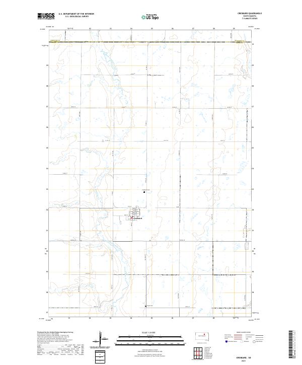
2021 Map of Cresbard
USGS Topo · Published 2021About this map
Cresbard serves as the central hub of this prairie landscape, where the town's street grid of Main St, Swift Ave, and Howard Ave meets the surrounding agricultural expanse. The topography is defined by the winding course of the North Fork Snake Creek, also labeled in sections as N Fork Snake Cr, which carves a path through the grid of section lines and county roads. This survey illustrates the organized land division typical of Faulk County, with long arterial routes like Co Rd 15 and Co Rd 2 connecting the isolated town to the broader region. Local history is anchored by the presence of Cresbard Cem just north of the village and Hope Cem to the south, marking the established roots of this community within the Dakota plains.
Find a feature on this map
38 named features on this map. Tap any name to fly to it.
Don’t see what you’re looking for? This feature index may not catch every label — zoom into the map to look around manually.
Map Details
Editions of this 2021 Cresbard Map
This is the sole edition of this map. No revisions or reprints were ever made.
Other maps of this area

1899 · Northville
USGS Topo · 1:125,000

1952 · Wecota
USGS Topo · 1:24,000

1952 · Faulkton East
USGS Topo · 1:24,000

1954 · Aberdeen
USGS Topo · 1:250,000

1956 · Aberdeen
USGS Topo · 1:250,000

1966 · Cresbard SE
USGS Topo · 1:24,000
1966 · Cresbard SW
USGS Topo · 1:24,000
1966 · Cresbard NE
USGS Topo · 1:24,000

1966 · Cresbard
USGS Topo · 1:24,000

1970 · Mina SW
USGS Topo · 1:24,000