1994 Map of Crescent Mills
USGS Topo · Published 1997About this map
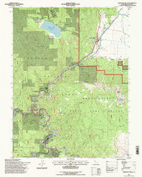
Crescent Mills serves as a focal point in this mountainous region of Plumas County, situated at the edge of the Indian Valley. The landscape is defined by the convergence of steep canyons and high ridges, notably Mount Hough and Hough Ridge, which overlook the winding course of the Feather River and Spanish Creek. Industrial and transit history is etched into the terrain through the Union Pacific railroad lines and several legacy mining operations, including the Arcadia Mine and the Cherokee Mine site near Round Valley Reservoir. Significant conservation and land management areas dominate the southern and central sections, specifically the Mount Hough State Game Refuge and the Butterfly Valley Botanical Area. To the north, the historic Emigrant Road traces the base of the mountains, while small settlements like Keddie and Paxton mark important rail junctions and river crossings.
Find a feature on this map
44 named features on this map. Tap any name to fly to it.
Don’t see what you’re looking for? This feature index may not catch every label — zoom into the map to look around manually.
Map Details
Editions of this 1994 Crescent Mills Map
This is the sole edition of this map. No revisions or reprints were ever made.
Other maps of this area

1886 · Honey Lake
USGS Topo · 1:250,000

1886 · Lassen Peak
USGS Topo · 1:250,000

1888 · Bidwell Bar
USGS Topo · 1:125,000

1891 · Bidwell Bar
USGS Topo · 1:125,000

1891 · Downieville
USGS Topo · 1:125,000

1891 · Honey Lake
USGS Topo · 1:250,000

1892 · Lassen Peak
USGS Topo · 1:250,000

1893 · Bidwell Bar
USGS Topo · 1:125,000

1893 · Honey Lake
USGS Topo · 1:250,000

1893 · Downieville
USGS Topo · 1:125,000