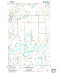
1991 Map of Creston
USGS Topo · Published 1995About this map
Flathead River meanders through this landscape, defining a complex hydrology of oxbows and wetlands in the Flathead Valley. The winding course of the river has left behind numerous named water bodies, including Egan Slough, McWenneger Slough, and Church Slough, which dominate the central terrain. These features, along with Half Moon Slough and Shaws Slough, suggest a floodplain where water has dictated the patterns of human settlement and land use. On the higher ground, rural life is marked by local landmarks like Fairview Sch, Egan Sch, and Hodgson Sch. To the west, the Stillwater State Game Preserve borders the river, while the small communities of Creston and Montford serve as local hubs. This survey reveals a transition between the managed waters of the valley floor and the recreational or agricultural areas near Lake Blaine in the northeast.
Find a feature on this map
21 named features on this map. Tap any name to fly to it.
Don’t see what you’re looking for? This feature index may not catch every label — zoom into the map to look around manually.
Map Details
Editions of this 1991 Creston Map
This is the sole edition of this map. No revisions or reprints were ever made.
Other maps of this area

1943 · Kalispell
USGS Topo · 1:125,000

1957 · Kalispell
USGS Topo · 1:250,000

1960 · Kalispell
USGS Topo · 1:250,000

1961 · Kalispell
USGS Topo · 1:250,000

1962 · Columbia Falls South
USGS Topo · 1:24,000

1962 · Doris Mountain
USGS Topo · 1:24,000

1962 · Rose Crossing
USGS Topo · 1:24,000

1962 · Lion Mountain
USGS Topo · 1:24,000

1962 · Somers
USGS Topo · 1:24,000

1962 · Creston
USGS Topo · 1:24,000