
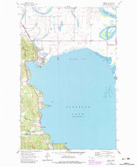
1962 Map of Somers
USGS Topo · Published 1964About this map
Somers serves as a focal point on the northern shores of Flathead Lake, where the Great Northern railway line terminates at a prominent Wharf. This 1962 field-checked survey captures the industrial and military presence of the era, notably the Kalispell Air Force Station located near Lakeside along the western shoreline. The landscape is defined by the transition from the flowing Flathead River and Fennon Slough into the broad expanse of Kalispell Bay.
Find a feature on this map
23 named features on this map. Tap any name to fly to it.
Don’t see what you’re looking for? This feature index may not catch every label — zoom into the map to look around manually.
Map Details
Editions of this 1962 Somers Map
2 editions found
Other maps of this area

1920 · Flathead Lake
USGS Topo · 1:125,000

1943 · Kalispell
USGS Topo · 1:125,000

1956 · Wallace
USGS Topo · 1:250,000

1957 · Kalispell
USGS Topo · 1:250,000

1960 · Kalispell
USGS Topo · 1:250,000

1960 · Wallace
USGS Topo · 1:250,000

1961 · Kalispell
USGS Topo · 1:250,000

1962 · Lion Mountain
USGS Topo · 1:24,000

1962 · Creston
USGS Topo · 1:24,000

1962 · Hash Mountain
USGS Topo · 1:24,000