
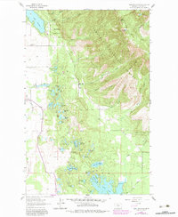
1962 Map of Hash Mountain
USGS Topo · Published 1964About this map
Flathead National Forest dominates the eastern landscape of this 1962 survey, where the peaks of Hash Mountain and Peters Ridge give way to a dense network of glacial lakes and small rural settlements. The transition from the high ridges down to the valley floor is marked by numerous water bodies, including Lake Blaine and Echo Lake, alongside smaller named features like Plummers L and Lake of the Woods.
Find a feature on this map
51 named features on this map. Tap any name to fly to it.
Don’t see what you’re looking for? This feature index may not catch every label — zoom into the map to look around manually.
Map Details
Editions of this 1962 Hash Mountain Map
2 editions found
Other maps of this area

1914 · Nyack
USGS Topo · 1:125,000

1943 · Kalispell
USGS Topo · 1:125,000

1957 · Kalispell
USGS Topo · 1:250,000

1960 · Kalispell
USGS Topo · 1:250,000

1960 · Cut Bank
USGS Topo · 1:250,000

1961 · Kalispell
USGS Topo · 1:250,000

1962 · Columbia Falls South
USGS Topo · 1:24,000

1962 · Doris Mountain
USGS Topo · 1:24,000

1962 · Somers
USGS Topo · 1:24,000

1962 · Creston
USGS Topo · 1:24,000