
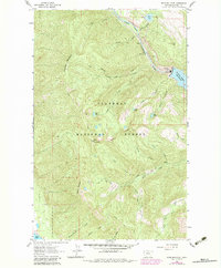
1962 Map of Doris Mountain
USGS Topo · Published 1964About this map
Flathead National Forest defines this high-elevation landscape, where the Hungry Horse Reservoir meets the industrial infrastructure of the Powerhouse and Substation. The 1962 survey captures a wilderness in transition, balancing the engineered utility of the South Fork Flathead River with an extensive network of traditional backcountry routes like the Aurora Trail and Doris Trail. These paths weave between prominent summits including Columbia Mountain and Doris Mountain, providing a detailed look at the drainage patterns of Doris Creek and Fawn Creek. Along the river’s edge, specific navigational and monitoring points such as the Gaging Sta and the sharp bend at Devils Elbow offer precise geographic markers for those studying the mid-century development of Montana's water resources and forest management.
Find a feature on this map
40 named features on this map. Tap any name to fly to it.
Don’t see what you’re looking for? This feature index may not catch every label — zoom into the map to look around manually.
Map Details
Editions of this 1962 Doris Mountain Map
2 editions found
Other maps of this area

1914 · Nyack
USGS Topo · 1:125,000

1943 · Kalispell
USGS Topo · 1:125,000

1957 · Kalispell
USGS Topo · 1:250,000

1960 · Kalispell
USGS Topo · 1:250,000

1960 · Cut Bank
USGS Topo · 1:250,000

1961 · Kalispell
USGS Topo · 1:250,000

1962 · Columbia Falls South
USGS Topo · 1:24,000

1962 · Hungry Horse
USGS Topo · 1:24,000

1962 · Creston
USGS Topo · 1:24,000

1962 · Hash Mountain
USGS Topo · 1:24,000