
1920 Map of Flathead Lake
USGS Topo · Published 1920About this map
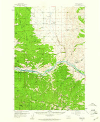
Flathead Lake dominates this progressive military survey, illustrating the complex hydrology and early development of the region during the transition following the opening of the Indian Reservation. The map details an extensive irrigation network essential to the era's agricultural expansion, featuring the Pablo Reservoir, Crow Creek Reservoir, and a web of waterways including the Feeder Canal and Dixon Polson Canal. This water infrastructure supported growing settlements like Polson, Ronan, and Pablo along the N. P. Ry. line.
Find a feature on this map
62 named features on this map. Tap any name to fly to it.
Don’t see what you’re looking for? This feature index may not catch every label — zoom into the map to look around manually.
Map Details
Editions of this 1920 Flathead Lake Map
This is the sole edition of this map. No revisions or reprints were ever made.
Other maps of this area

1914 · Nyack
USGS Topo · 1:125,000

1921 · Elbow Lake
USGS Topo · 1:125,000

1943 · Kalispell
USGS Topo · 1:125,000

1955 · Choteau
USGS Topo · 1:250,000

1956 · Wallace
USGS Topo · 1:250,000

1957 · Choteau
USGS Topo · 1:250,000

1957 · Kalispell
USGS Topo · 1:250,000

1958 · Choteau
USGS Topo · 1:250,000
1959 · Perma
USGS Topo · 1:62,500

1960 · Kalispell
USGS Topo · 1:250,000