
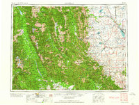
1958 Map of Choteau
USGS Topo · Published 1958About this map
The Continental Divide dictates the geography of this mid-century Montana landscape, splitting the region between the high peaks of the Lewis and Clark Range and the agricultural plains to the east. The eastern foothills are defined by the water management of the day, featuring Bynum Reservoir, Pishkun Reservoir, and Willow Creek Reservoir which feed the Teton River and Sun River valleys. Near the mountain front, the town of Choteau serves as a hub alongside the Great Northern rail line, while Augusta and Gilman anchor the southern ranching districts.
Find a feature on this map
78 named features on this map. Tap any name to fly to it.
Don’t see what you’re looking for? This feature index may not catch every label — zoom into the map to look around manually.
Map Details
Editions of this 1958 Choteau Map
2 editions found
Other maps of this area

1886 · Great Falls
USGS Topo · 1:250,000

1886 · Fort Logan
USGS Topo · 1:250,000

1889 · Helena
USGS Topo · 1:250,000

1893 · Helena
USGS Topo · 1:250,000

1899 · Helena
USGS Topo · 1:250,000

1902 · Ovando
USGS Topo · 1:125,000

1903 · Saypo
USGS Topo · 1:125,000

1903 · Coopers Lake
USGS Topo · 1:125,000

1903 · Bonner
USGS Topo · 1:125,000

1903 · Helena
USGS Topo · 1:250,000