
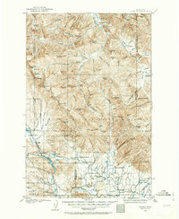
1902 Map of Ovando
USGS Topo · Published 1960About this map
The Blackfoot River and the South Fork Flathead River anchor this turn-of-the-century Montana landscape, where the transition from high mountain peaks to ranching valleys is clearly marked. The settlement of Ovando sits as a central hub for the various family-named homesteads and agricultural operations that define the region's early 20th-century economy. These include Jakway's Ranch, Boyd's Ranch, and Hanson's Ranch clustered near the river plains, while higher elevations are dotted with outposts like Upper Cabin and Rangers Cabin.
Find a feature on this map
124 named features on this map. Tap any name to fly to it.
Don’t see what you’re looking for? This feature index may not catch every label — zoom into the map to look around manually.
Map Details
Editions of this 1902 Ovando Map
2 editions found
Other maps of this area

1889 · Helena
USGS Topo · 1:250,000

1893 · Helena
USGS Topo · 1:250,000

1899 · Helena
USGS Topo · 1:250,000

1903 · Saypo
USGS Topo · 1:125,000

1903 · Coopers Lake
USGS Topo · 1:125,000

1903 · Bonner
USGS Topo · 1:125,000

1903 · Helena
USGS Topo · 1:250,000

1905 · Ovando
USGS Topo · 1:125,000

1919 · Drummond
USGS Topo · 1:125,000

1921 · Drummond
USGS Topo · 1:125,000