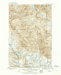
1902 Map of Ovando
USGS Topo · Published 1963About this map
Ovando and the surrounding ranchlands of the Blackfoot River valley are shown here just after the turn of the century. The map captures a landscape of transition, where early settlement hubs like Woodworth and Blanchard sit at the edge of the Lolo National Forest and Flathead National Forest. This era was defined by isolated outposts and homesteads, evidenced by the numerous family-named landmarks such as Danaher's Ranch, Seeley's Ranch, and Railey's Ranch.
Find a feature on this map
120 named features on this map. Tap any name to fly to it.
Don’t see what you’re looking for? This feature index may not catch every label — zoom into the map to look around manually.
Map Details
Editions of this 1902 Ovando Map
2 editions found
Other maps of this area

1889 · Helena
USGS Topo · 1:250,000

1893 · Helena
USGS Topo · 1:250,000

1899 · Helena
USGS Topo · 1:250,000

1902 · Ovando
USGS Topo · 1:125,000

1903 · Saypo
USGS Topo · 1:125,000

1903 · Coopers Lake
USGS Topo · 1:125,000

1903 · Bonner
USGS Topo · 1:125,000

1903 · Helena
USGS Topo · 1:250,000

1905 · Ovando
USGS Topo · 1:125,000
1919 · Drummond
USGS Topo · 1:125,000