
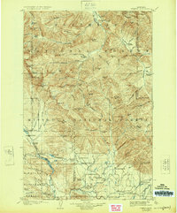
1905 Map of Ovando
USGS Topo · Published 1905About this map
The Lewis and Clarke Forest Reserve dominates this early twentieth-century landscape, capturing a wilderness defined by homesteading and timber production. Settlements like Ovando and Blanchard serve as small hubs for a vast network of family cattle and sheep operations, including Diltz Ranch, Railey's Ranch, and Danaher's Ranch. The map highlights the early industrial infrastructure of the region, noting a Logging Camp and Headquarters Camp near the Clearwater River, which likely supported timber transport to mills outside the quadrangle.
Find a feature on this map
112 named features on this map. Tap any name to fly to it.
Don’t see what you’re looking for? This feature index may not catch every label — zoom into the map to look around manually.
Map Details
Editions of this 1905 Ovando Map
2 editions found
Other maps of this area

1889 · Helena
USGS Topo · 1:250,000

1893 · Helena
USGS Topo · 1:250,000

1899 · Helena
USGS Topo · 1:250,000

1902 · Ovando
USGS Topo · 1:125,000

1903 · Saypo
USGS Topo · 1:125,000

1903 · Coopers Lake
USGS Topo · 1:125,000

1903 · Bonner
USGS Topo · 1:125,000

1903 · Helena
USGS Topo · 1:250,000

1919 · Drummond
USGS Topo · 1:125,000

1921 · Drummond
USGS Topo · 1:125,000