
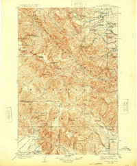
1903 Map of Coopers Lake
USGS Topo · Published 1903About this map
Lewis and Clarke Forest Reserve covers the heart of this 1900 survey, where the Continental Divide winds through the high peaks of the Alice Mountains and Scapegoat Mt.. The landscape is defined by the headwaters of the Blackfoot River and Dearborn River, reflecting an era of early high-country ranching and mineral exploration. Scattered homesteads like Walrath's Ranch and Smith's Ranch dot the valley floors near Swallow Canyon, while small-scale industrial operations such as White's Sawmill and the Klondike Mine suggest a localized economy based on timber and ore. In the south, Kleinschmidt Flat provides a rare expanse of level ground near the settlement of Evans, positioned along the boundary between Lewis and Clark and Powell counties. The presence of several Copper Camps and the Porto Rico Mine highlights the prospecting activity that shaped the development of this Montana wilderness.
Find a feature on this map
95 named features on this map. Tap any name to fly to it.
Don’t see what you’re looking for? This feature index may not catch every label — zoom into the map to look around manually.
Map Details
Editions of this 1903 Coopers Lake Map
3 editions found

Other maps of this area

1889 · Helena
USGS Topo · 1:250,000

1893 · Helena
USGS Topo · 1:250,000

1899 · Helena
USGS Topo · 1:250,000

1902 · Ovando
USGS Topo · 1:125,000

1903 · Saypo
USGS Topo · 1:125,000

1903 · Helena
USGS Topo · 1:250,000

1905 · Ovando
USGS Topo · 1:125,000
1919 · Drummond
USGS Topo · 1:125,000

1920 · Choteau
USGS Topo · 1:125,000
1921 · Drummond
USGS Topo · 1:125,000