
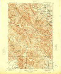
1903 Map of Coopers Lake
USGS Topo · Published 1949About this map
The Continental Divide winds through this turn-of-the-century landscape, marking the high country of the Lewis and Clark National Forest and Flathead National Forest. This 1900 survey documents an era of active resource extraction and high-altitude ranching, evidenced by the cluster of mining claims near Mineral Hill including the Klondike Mine and Porto Rico Mine. Settlers established a series of remote outposts along the mountain drainages, such as Witmer Bros Ranch and Bavieres Ranch, while early industrial activity is marked by Whites Sawmill and Copper Camp. The topography is dominated by peaks like Scapegoat Mt. and Stonewall Mt., with the expansive Kleinschmidt Flat providing a rare break in the terrain near Coopers Lake. The presence of the Canal near Lincoln Gulch points to the early engineering efforts required to manage water for mining and agriculture in this environment.
Find a feature on this map
94 named features on this map. Tap any name to fly to it.
Don’t see what you’re looking for? This feature index may not catch every label — zoom into the map to look around manually.
Map Details
Editions of this 1903 Coopers Lake Map
3 editions found
Other maps of this area

1889 · Helena
USGS Topo · 1:250,000

1893 · Helena
USGS Topo · 1:250,000

1899 · Helena
USGS Topo · 1:250,000

1902 · Ovando
USGS Topo · 1:125,000

1903 · Saypo
USGS Topo · 1:125,000

1903 · Coopers Lake
USGS Topo · 1:125,000

1903 · Helena
USGS Topo · 1:250,000

1905 · Ovando
USGS Topo · 1:125,000
1919 · Drummond
USGS Topo · 1:125,000

1920 · Choteau
USGS Topo · 1:125,000