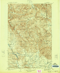
1905 Map of Ovando
USGS Topo · Published 1924About this map
Ovando and the surrounding river valleys are captured here just after the turn of the century, during a period of early settlement and ranching development. The landscape is defined by the high peaks of the Continental Divide and the waters of the Blackfoot River, which serves as a primary drainage for numerous family-run operations. Genealogists and local historians will find an extensive network of early homesteads, including Danaher's Ranch, Railey's Ranch, and Morrell's Ranch, illustrating how the region's flatlands were claimed for agriculture and livestock.
Find a feature on this map
122 named features on this map. Tap any name to fly to it.
Don’t see what you’re looking for? This feature index may not catch every label — zoom into the map to look around manually.
Map Details
Editions of this 1905 Ovando Map
2 editions found
Other maps of this area

1889 · Helena
USGS Topo · 1:250,000

1893 · Helena
USGS Topo · 1:250,000

1899 · Helena
USGS Topo · 1:250,000

1902 · Ovando
USGS Topo · 1:125,000

1903 · Saypo
USGS Topo · 1:125,000

1903 · Coopers Lake
USGS Topo · 1:125,000

1903 · Bonner
USGS Topo · 1:125,000

1903 · Helena
USGS Topo · 1:250,000

1905 · Ovando
USGS Topo · 1:125,000

1919 · Drummond
USGS Topo · 1:125,000