
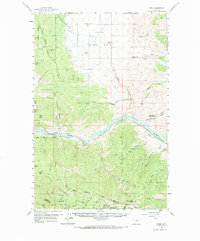
1959 Map of Perma
USGS Topo · Published 1961About this map
The Northern Pacific Railroad follows the winding course of the Flathead River through this mid-century landscape, where the valley floor transitions into the high Camas Prairie Basin. This map captures a rural economy of the late 1950s, marked by artesian wells and the geothermal Green Springs (Hot). Settlement is concentrated near Camas, where several cemeteries including Camas Cem and Hoministo Cem offer valuable data for genealogical research.
Find a feature on this map
60 named features on this map. Tap any name to fly to it.
Don’t see what you’re looking for? This feature index may not catch every label — zoom into the map to look around manually.
Map Details
Editions of this 1959 Perma Map
2 editions found
Other maps of this area

1920 · Flathead Lake
USGS Topo · 1:125,000

1956 · Wallace
USGS Topo · 1:250,000

1959 · Tarkio
USGS Topo · 1:62,500

1959 · Alberton
USGS Topo · 1:62,500

1959 · Plains
USGS Topo · 1:62,500

1960 · Wallace
USGS Topo · 1:250,000

1960 · Superior
USGS Topo · 1:62,500

1964 · Mc Donald
USGS Topo · 1:24,000

1964 · Melton Ranch
USGS Topo · 1:24,000

1964 · Markle Pass
USGS Topo · 1:24,000