
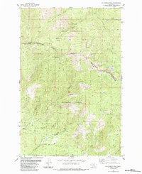
1964 Map of Mc Donald
USGS Topo · Published 1966About this map
The Flathead River carves a central path through this mid-1960s landscape, serving as the primary corridor for both natural drainage and industrial transport. The Northern Pacific railroad follows the southern bank of the river, while a Pipeline cuts across the western hills, reflecting the infrastructure required to navigate this portion of Sanders County. To the south, industrial activity is centered at the Green Mountain Mine, situated near the confluence of Revais Creek and its West Fork.
Find a feature on this map
16 named features on this map. Tap any name to fly to it.
Don’t see what you’re looking for? This feature index may not catch every label — zoom into the map to look around manually.
Map Details
Editions of this 1964 Mc Donald Map
This is the sole edition of this map. No revisions or reprints were ever made.
Other maps of this area

1956 · Wallace
USGS Topo · 1:250,000

1959 · Tarkio
USGS Topo · 1:62,500

1959 · Alberton
USGS Topo · 1:62,500

1959 · Perma
USGS Topo · 1:62,500

1960 · Wallace
USGS Topo · 1:250,000

1964 · Dixon
USGS Topo · 1:24,000

1964 · Melton Ranch
USGS Topo · 1:24,000

1965 · Sloan
USGS Topo · 1:24,000

1984 · Stark North
USGS Topo · 1:24,000
1984 · Mc Cormick Peak
USGS Topo · 1:24,000