
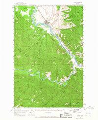
1959 Map of Plains
USGS Topo · Published 1961About this map
Clark Fork and the Flathead River converge near Paradise, carving a deep corridor through the Coeur d'Alene Mountains of northwestern Montana. In the late 1950s, this landscape was defined by the Northern Pacific railroad, which tracks along the riverbanks, connecting small river-bound settlements like Plains and Donlan. The town of Plains serves as a local hub, featuring an Airport, County Fairgrounds, and a Ranger Station adjacent to the vast Lolo National Forest.
Find a feature on this map
52 named features on this map. Tap any name to fly to it.
Don’t see what you’re looking for? This feature index may not catch every label — zoom into the map to look around manually.
Map Details
Editions of this 1959 Plains Map
2 editions found
Other maps of this area

1918 · St Regis
USGS Topo · 1:125,000

1919 · St. Regis
USGS Topo · 1:125,000

1937 · Thompson Falls
USGS Topo · 1:125,000

1956 · St Regis
USGS Topo · 1:62,500

1956 · Wallace
USGS Topo · 1:250,000

1957 · Illinois Peak
USGS Topo · 1:62,500

1959 · Tarkio
USGS Topo · 1:62,500

1959 · Perma
USGS Topo · 1:62,500

1960 · Wallace
USGS Topo · 1:250,000

1960 · Superior
USGS Topo · 1:62,500