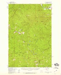
1957 Map of Illinois Peak
USGS Topo · Published 1959About this map
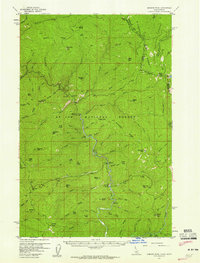
The Lolo National Forest, St Joe National Forest, and Clearwater National Forest converge in this high-altitude landscape along the Montana-Idaho border during the late 1950s. Mining activity is prominent across the terrain, with claims such as the American Gold Mine, Eagle Cliff Mine, and Gildersleeve Mine clustered near the many gulches and creeks. The northeast corner of the map reveals the critical transportation corridor of the Clark Fork river valley, where the Chicago Milwaukee St Paul and Pacific and the Northern Pacific railroads parallel each other through the mountains. Observation points like Wade Lookout Peak and the Illinois Peak summit reflect the region's management for fire watch and surveying. Numerous alpine water bodies, including Diamond Lake and the Bonanza Lakes, are scattered among peaks like Torino Peak and Cascade Peak.
Find a feature on this map
108 named features on this map. Tap any name to fly to it.
Don’t see what you’re looking for? This feature index may not catch every label — zoom into the map to look around manually.
Map Details
Editions of this 1957 Illinois Peak Map
2 editions found
Other maps of this area

1911 · Lolo
USGS Topo · 1:250,000

1913 · Lolo
USGS Topo · 1:250,000

1918 · St Regis
USGS Topo · 1:125,000

1919 · St. Regis
USGS Topo · 1:125,000
1956 · St Regis
USGS Topo · 1:62,500

1956 · Wallace
USGS Topo · 1:250,000

1956 · Hamilton
USGS Topo · 1:250,000
1957 · Haugan
USGS Topo · 1:62,500
1957 · Simmons Peak
USGS Topo · 1:62,500

1959 · Hamilton
USGS Topo · 1:250,000