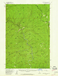
1957 Map of Simmons Peak
USGS Topo · Published 1959About this map
The St Joe National Forest dominates this landscape, where the Idaho-Montana border traces the high divide of the Bitterroot Range. In the late 1950s, the region was defined by its network of forest management and early recreation sites along the winding river. The Red Ives Ranger Sta serves as a central hub for the area, surrounded by numerous primitive camps like the Conrad Crossing Campground and Fly Flat Campground.
Find a feature on this map
92 named features on this map. Tap any name to fly to it.
Don’t see what you’re looking for? This feature index may not catch every label — zoom into the map to look around manually.
Map Details
Editions of this 1957 Simmons Peak Map
2 editions found

Other maps of this area

1911 · Lolo
USGS Topo · 1:250,000

1913 · Lolo
USGS Topo · 1:250,000

1914 · Avery
USGS Topo · 1:125,000

1917 · Avery
USGS Topo · 1:125,000

1918 · St Regis
USGS Topo · 1:125,000

1919 · St. Regis
USGS Topo · 1:125,000

1923 · Washington Creek
USGS Topo · 1:125,000
1956 · St Regis
USGS Topo · 1:62,500
1956 · Saltese
USGS Topo · 1:62,500

1956 · Wallace
USGS Topo · 1:250,000