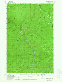
1957 Map of Simmons Peak
USGS Topo · Published 1965About this map
St Joe National Forest and Lolo National Forest dominate this mid-century topographic record, which straddles the high mountain boundary between Shoshone County, Idaho, and Mineral County, Montana. The St Joe River carves a deep path through the center of the sheet, served by the primary transit corridor of St Joe River Road. A focal point of regional administration and backcountry activity is the Red Ives Ranger Sta, situated near the confluence of several drainages including Indian Creek and Red Ives Peak.
Find a feature on this map
79 named features on this map. Tap any name to fly to it.
Don’t see what you’re looking for? This feature index may not catch every label — zoom into the map to look around manually.
Map Details
Editions of this 1957 Simmons Peak Map
2 editions found

Other maps of this area

1911 · Lolo
USGS Topo · 1:250,000

1913 · Lolo
USGS Topo · 1:250,000

1914 · Avery
USGS Topo · 1:125,000

1917 · Avery
USGS Topo · 1:125,000

1918 · St Regis
USGS Topo · 1:125,000

1919 · St. Regis
USGS Topo · 1:125,000

1923 · Washington Creek
USGS Topo · 1:125,000

1956 · St Regis
USGS Topo · 1:62,500

1956 · Saltese
USGS Topo · 1:62,500

1956 · Wallace
USGS Topo · 1:250,000