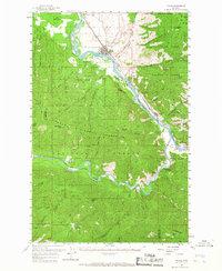
1959 Map of Plains
USGS Topo · Published 1967About this map
The confluence of the Flathead River and the Clark Fork anchors this mid-century survey of western Montana. The town of Plains serves as the primary regional hub, situated along the Northern Pacific railroad as it follows the river valley. The landscape is dominated by the Coeur d Alene Mountains and the heavily forested slopes of the Lolo National Forest, where industrial activity is visible at sites like the Nancy Lee Mine and a local Gravel Pit.
Find a feature on this map
42 named features on this map. Tap any name to fly to it.
Don’t see what you’re looking for? This feature index may not catch every label — zoom into the map to look around manually.
Map Details
Editions of this 1959 Plains Map
2 editions found
Other maps of this area

1918 · St Regis
USGS Topo · 1:125,000

1919 · St. Regis
USGS Topo · 1:125,000

1937 · Thompson Falls
USGS Topo · 1:125,000

1956 · St Regis
USGS Topo · 1:62,500

1956 · Wallace
USGS Topo · 1:250,000

1957 · Illinois Peak
USGS Topo · 1:62,500

1959 · Tarkio
USGS Topo · 1:62,500

1959 · Perma
USGS Topo · 1:62,500

1959 · Plains
USGS Topo · 1:62,500

1960 · Wallace
USGS Topo · 1:250,000