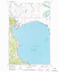
1962 Map of Somers
USGS Topo · Published 1983About this map
The western shores of Flathead Lake and the northern reach of Kalispell Bay dominate this topographical study, which highlights the industrial and military presence in Flathead County during the mid-20th century. The settlement of Somers is positioned at the lake's head, where a prominent Wharf and the Burlington Northern railroad line once signaled a hub of regional transport and timber activity. Further south, the shoreline community of Lakeside sits adjacent to the Kalispell Air Force Station, a Cold War era installation tucked against the rising terrain near Stoner Creek.
Find a feature on this map
22 named features on this map. Tap any name to fly to it.
Don’t see what you’re looking for? This feature index may not catch every label — zoom into the map to look around manually.
Map Details
Editions of this 1962 Somers Map
2 editions found
Other maps of this area

1920 · Flathead Lake
USGS Topo · 1:125,000

1943 · Kalispell
USGS Topo · 1:125,000

1956 · Wallace
USGS Topo · 1:250,000

1957 · Kalispell
USGS Topo · 1:250,000

1960 · Kalispell
USGS Topo · 1:250,000

1960 · Wallace
USGS Topo · 1:250,000

1961 · Kalispell
USGS Topo · 1:250,000

1962 · Lion Mountain
USGS Topo · 1:24,000

1962 · Somers
USGS Topo · 1:24,000

1962 · Creston
USGS Topo · 1:24,000