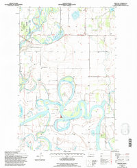
1994 Map of Creston
USGS Topo · Published 1996About this map
The Flathead River meanders across this northern Montana valley, creating a complex network of oxbow lakes and bypasses during the mid-1990s. The landscape is defined by these distinctive water features, including the expansive Egan Slough, McWenneger Slough, and Church Slough, which illustrate the hydrological evolution of the river basin. Along the eastern edge, the settlement of Creston sits near the intersection of local routes, while the Fair Mont Egan School serves as a local landmark for the surrounding rural community. To the northwest, the State Wildlife Management Area borders the river, preserving a portion of the riparian environment near Shaws Slough. This survey captures the region's character as a mix of agricultural plots and managed wetlands before late-twentieth-century development altered the rural pattern.
Find a feature on this map
20 named features on this map. Tap any name to fly to it.
Don’t see what you’re looking for? This feature index may not catch every label — zoom into the map to look around manually.
Map Details
Editions of this 1994 Creston Map
This is the sole edition of this map. No revisions or reprints were ever made.
Other maps of this area

1943 · Kalispell
USGS Topo · 1:125,000

1957 · Kalispell
USGS Topo · 1:250,000

1960 · Kalispell
USGS Topo · 1:250,000

1961 · Kalispell
USGS Topo · 1:250,000

1962 · Columbia Falls South
USGS Topo · 1:24,000

1962 · Doris Mountain
USGS Topo · 1:24,000

1962 · Rose Crossing
USGS Topo · 1:24,000

1962 · Lion Mountain
USGS Topo · 1:24,000

1962 · Somers
USGS Topo · 1:24,000

1962 · Creston
USGS Topo · 1:24,000