
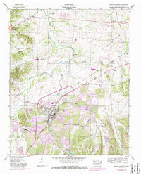
1936 Map of Crestview
USGS Topo · Published 1936About this map
Louisville and Nashville Railroad tracks dominate the center of this 1930s landscape, illustrating the critical role of rail transport in the rural highlands near the intersection of Lawrence, Maury, and Lewis Counties. The Tennessee Valley Authority's involvement is evident in the presence of the Tennessee Electric Power Company Transmission Line, which cuts a distinct path through the wooded terrain. Settlements like Summertown and Crestview serve as local hubs, connected by State Highway No 20. The map documents a community structure built around education and faith, featuring rural anchors such as Porter Chapel Sch, New Salem Sch, and Pleasant Garden Ch. Natural features including Rattlesnake Falls and the winding Buffalo River define the local topography, while numerous branches like Bargain Branch and Sheppard Branch suggest a well-watered but broken landscape.
Find a feature on this map
33 named features on this map. Tap any name to fly to it.
Don’t see what you’re looking for? This feature index may not catch every label — zoom into the map to look around manually.
Map Details
Editions of this 1936 Crestview Map
This is the sole edition of this map. No revisions or reprints were ever made.
Other maps of this area

1901 · Colombia
USGS Topo · 1:125,000

1936 · Sandy Hook
USGS Topo · 1:24,000

1936 · Deerfield
USGS Topo · 1:24,000

1936 · Mt Joy
USGS Topo · 1:24,000

1936 · Henryville
USGS Topo · 1:24,000

1936 · Campbellsville
USGS Topo · 1:24,000

1936 · Ethridge
USGS Topo · 1:24,000

1936 · Mount Pleasant
USGS Topo · 1:24,000

1936 · Gordonsburg
USGS Topo · 1:24,000
1946 · Mount Pleasant
USGS Topo · 1:24,000