
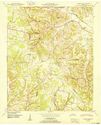
1936 Map of Ethridge
USGS Topo · Published 1936About this map
Ethridge and the surrounding rural landscapes of Lawrence County are documented here during the mid-1930s. The settlement pattern is defined by a dense network of country schools and family churches, such as Union Hill Sch and Shady Grove Ch, which served as the social anchors for this agricultural region. The Louisville and Nashville Railroad runs North-South through the center of the sheet, paralleling the Nashville and Jackson Highway and facilitating the movement of local goods.
Find a feature on this map
43 named features on this map. Tap any name to fly to it.
Don’t see what you’re looking for? This feature index may not catch every label — zoom into the map to look around manually.
Map Details
Editions of this 1936 Ethridge Map
This is the sole edition of this map. No revisions or reprints were ever made.
Other maps of this area

1936 · Sandy Hook
USGS Topo · 1:24,000

1936 · Deerfield
USGS Topo · 1:24,000

1936 · Henryville
USGS Topo · 1:24,000

1936 · Campbellsville
USGS Topo · 1:24,000

1936 · Lawrenceburg
USGS Topo · 1:24,000

1936 · Long Branch
USGS Topo · 1:24,000

1936 · Crestview
USGS Topo · 1:24,000

1936 · Bodenham
USGS Topo · 1:24,000

1948 · Bodenham
USGS Topo · 1:24,000
1950 · Bodenham
USGS Topo · 1:24,000