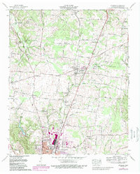
1966 Map of Ethridge
USGS Topo · Published 1989About this map
The Louisville and Nashville railroad corridor anchors this mid-century view of central Tennessee, connecting the primary settlements of Ethridge and the northern reaches of Lawrenceburg. The landscape is a mix of small crossroads communities and rural institutions, evidenced by the numerous cemeteries like Yoder Cem and Kidd Cem that served local families. Significant infrastructure of the era is visible, including the Brier Hill Fire Tower on Beier Hill and the Radio tower (WDXE) near the Vocational Center.
Find a feature on this map
67 named features on this map. Tap any name to fly to it.
Don’t see what you’re looking for? This feature index may not catch every label — zoom into the map to look around manually.
Map Details
Editions of this 1966 Ethridge Map
2 editions found
Other maps of this area

1936 · Sandy Hook
USGS Topo · 1:24,000

1936 · Deerfield
USGS Topo · 1:24,000

1936 · Henryville
USGS Topo · 1:24,000

1936 · Campbellsville
USGS Topo · 1:24,000

1936 · Lawrenceburg
USGS Topo · 1:24,000

1936 · Ethridge
USGS Topo · 1:24,000

1936 · Long Branch
USGS Topo · 1:24,000

1936 · Crestview
USGS Topo · 1:24,000

1936 · Bodenham
USGS Topo · 1:24,000

1948 · Bodenham
USGS Topo · 1:24,000