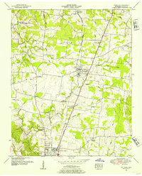
1951 Map of Ethridge
USGS Topo · Published 1954About this map
The Louisville and Nashville railroad serves as the central artery through this early 1950s Lawrence County landscape, connecting the agricultural hub of Ethridge with the northern outskirts of Lawrenceburg. This survey, conducted by the Tennessee Valley Authority and the Geological Survey, reveals a rural network of small communities and family-named landmarks. Features like the Lawrenceburg Sanitarium and the nearby County Home highlight the social infrastructure of the era, while the prevalence of rural congregations such as Freedom Hill Church and Shady Grove Ch underscores the region's communal life.
Find a feature on this map
47 named features on this map. Tap any name to fly to it.
Don’t see what you’re looking for? This feature index may not catch every label — zoom into the map to look around manually.
Map Details
Editions of this 1951 Ethridge Map
This is the sole edition of this map. No revisions or reprints were ever made.
Other maps of this area

1936 · Sandy Hook
USGS Topo · 1:24,000

1936 · Deerfield
USGS Topo · 1:24,000

1936 · Henryville
USGS Topo · 1:24,000

1936 · Campbellsville
USGS Topo · 1:24,000

1936 · Lawrenceburg
USGS Topo · 1:24,000

1936 · Ethridge
USGS Topo · 1:24,000

1936 · Long Branch
USGS Topo · 1:24,000

1936 · Crestview
USGS Topo · 1:24,000

1936 · Bodenham
USGS Topo · 1:24,000

1948 · Bodenham
USGS Topo · 1:24,000