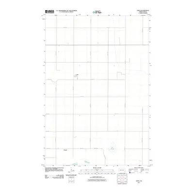
2011 Map of Crete
USGS Topo · Published 2011About this map
Crete serves as the primary focal point of this rural Sargent County landscape, centered at the intersection of Main St and 2nd St. The town's grid provides a structured anchor in an area otherwise dominated by the vast, open sections typical of North Dakota's prairie. South of the townsite, the small settlement of Hample sits along the section line, marking another node of human habitation in this agricultural expanse. The topography is defined by significant wetlands and water bodies, most notably the expansive Dill Slough and the nearby waters of Lake Schimmer and Lake Taayer. This 2011 survey captures the region's enduring character, where the surveyor’s grid of numeric avenues, such as 117th Ave SE and 120th Ave SE, dictates the flow of movement between isolated farmsteads and the central village.
Find a feature on this map
20 named features on this map. Tap any name to fly to it.
Don’t see what you’re looking for? This feature index may not catch every label — zoom into the map to look around manually.
Map Details
Editions of this 2011 Crete Map
This is the sole edition of this map. No revisions or reprints were ever made.
Other maps of this area

1894 · Oakes
USGS Topo · 1:62,500

1895 · Lamoure
USGS Topo · 1:125,000

1918 · La Moure
USGS Topo · 1:125,000

1952 · Oakes
USGS Topo · 1:24,000

1952 · Crete
USGS Topo · 1:24,000

1953 · Jamestown
USGS Topo · 1:250,000

1953 · Fargo
USGS Topo · 1:250,000
1955 · Oakes SE
USGS Topo · 1:24,000

1956 · Fargo
USGS Topo · 1:250,000

1956 · Jamestown
USGS Topo · 1:250,000