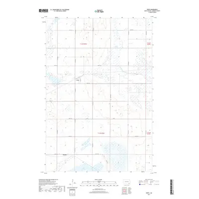
2017 Map of Crete
USGS Topo · Published 2017About this map
Crete and Hample anchor this agricultural landscape in Sargent County, where the section-line grid of the Public Land Survey System defines the movement of modern roads like 116th Ave SE and 88th St SE. The terrain is characterized by numerous seasonal wetlands and depressions, notably Bruns Slough to the north and Dill Slough further south. These features are typical of the prairie pothole region, where drainage patterns are often discontinuous and centered on local basins. In the southern portion of the map, Lake Taayer provides a significant water body amidst the surrounding fields. The infrastructure, including Co Rd 1, supports a dispersed rural population centered on these small established settlements and the connecting county road network.
Find a feature on this map
25 named features on this map. Tap any name to fly to it.
Don’t see what you’re looking for? This feature index may not catch every label — zoom into the map to look around manually.
Map Details
Editions of this 2017 Crete Map
This is the sole edition of this map. No revisions or reprints were ever made.
Other maps of this area

1894 · Oakes
USGS Topo · 1:62,500

1895 · Lamoure
USGS Topo · 1:125,000

1918 · La Moure
USGS Topo · 1:125,000

1952 · Oakes
USGS Topo · 1:24,000

1952 · Crete
USGS Topo · 1:24,000

1953 · Jamestown
USGS Topo · 1:250,000

1953 · Fargo
USGS Topo · 1:250,000
1955 · Oakes SE
USGS Topo · 1:24,000

1956 · Fargo
USGS Topo · 1:250,000

1956 · Jamestown
USGS Topo · 1:250,000