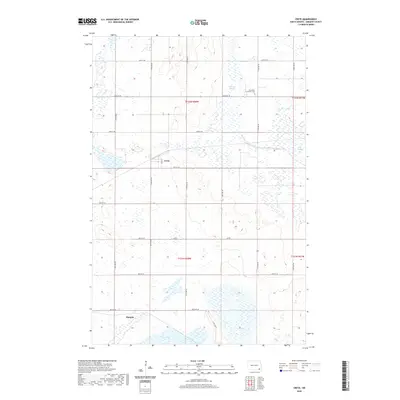
2020 Map of Crete
USGS Topo · Published 2020About this map
Crete stands as the primary settlement in this corner of Sargent County, situated along Main St in a landscape defined by expansive wetlands and prairie sloughs. The township's water-rich geography is marked by Bruns Slough, Big Slough, and Dill Slough, which dominate the eastern and central sections of the survey. To the southwest, Lake Taayer borders the small settlement of Hample, which sits at the junction of 88th St SE and 116th Ave SE. The grid of section lines and gravel roads reveals a pattern of rural continuity, where the Immanuel Lutheran Cem in the northeast serves as a silent landmark for local family history. This 2020 edition provides a modern topographic record of these small agrarian communities and the hydrographic features that have shaped the region since its early development.
Find a feature on this map
28 named features on this map. Tap any name to fly to it.
Don’t see what you’re looking for? This feature index may not catch every label — zoom into the map to look around manually.
Map Details
Editions of this 2020 Crete Map
This is the sole edition of this map. No revisions or reprints were ever made.
Other maps of this area

1894 · Oakes
USGS Topo · 1:62,500

1895 · Lamoure
USGS Topo · 1:125,000

1918 · La Moure
USGS Topo · 1:125,000

1952 · Oakes
USGS Topo · 1:24,000

1952 · Crete
USGS Topo · 1:24,000

1953 · Jamestown
USGS Topo · 1:250,000

1953 · Fargo
USGS Topo · 1:250,000
1955 · Oakes SE
USGS Topo · 1:24,000

1956 · Fargo
USGS Topo · 1:250,000

1956 · Jamestown
USGS Topo · 1:250,000