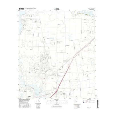
2016 Map of Crosby
USGS Topo · Published 2016About this map
The unincorporated community of Crosby serves as the focal point of this coastal prairie landscape, where the residential expansion of the Houston area meets established agricultural and industrial infrastructure. The map details a complex water management system including the San Jacinto River Authority Canal and various reservoirs like the Enderli Reservoir, supporting the region's transition from rural acreage to suburban development. Further south, the settlements of Barrett and Sheldon are depicted alongside the winding San Jacinto River, which feeds into Lake Houston. The presence of numerous specialized industrial sites, such as Sludge Pond Number 1 and Sludge Fill Pond Number 1, highlights the technical land use common in the Harris County industrial corridor. Genealogists will find several burial grounds documented, including Crosby Cem, Evergreen Cem, and Sacred Heart Cem, providing essential markers for local family history research in this rapidly changing territory.
Find a feature on this map
176 named features on this map. Tap any name to fly to it.
Don’t see what you’re looking for? This feature index may not catch every label — zoom into the map to look around manually.
Map Details
Editions of this 2016 Crosby Map
This is the sole edition of this map. No revisions or reprints were ever made.
Other maps of this area

1916 · Burnett Bay
USGS Topo · 1:24,000

1916 · Crosby
USGS Topo · 1:24,000

1916 · Fauna
USGS Topo · 1:24,000

1916 · Harmaston
USGS Topo · 1:24,000

1916 · Moonshine Hill
USGS Topo · 1:24,000

1916 · Cedar Bayou
USGS Topo · 1:24,000

1916 · Huffman
USGS Topo · 1:24,000

1919 · Crosby
USGS Topo · 1:31,680

1919 · Cedar Bayou
USGS Topo · 1:31,680
1920 · Fauna
USGS Topo · 1:31,680