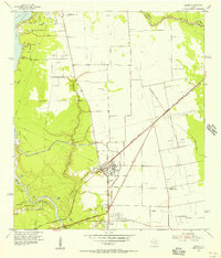
1954 Map of Crosby
USGS Topo · Published 1956About this map
The San Jacinto River shapes the western boundary of this Harris County landscape, which in the mid-1950s was a hub of industrial activity and established rural settlements. Crosby serves as the central focal point, showing a concentrated cluster of civic infrastructure including a Grade Sch, High Sch, and nearby Fairground. The presence of numerous Oil Wells and a complex network of pipelines near the Spoil Bank and Rankin Oil Field indicates the region's heavy reliance on the petroleum industry.
Find a feature on this map
34 named features on this map. Tap any name to fly to it.
Don’t see what you’re looking for? This feature index may not catch every label — zoom into the map to look around manually.
Map Details
Editions of this 1954 Crosby Map
This is the sole edition of this map. No revisions or reprints were ever made.
Other maps of this area

1916 · Burnett Bay
USGS Topo · 1:24,000

1916 · Crosby
USGS Topo · 1:24,000

1916 · Fauna
USGS Topo · 1:24,000

1916 · Harmaston
USGS Topo · 1:24,000

1916 · Moonshine Hill
USGS Topo · 1:24,000

1916 · Cedar Bayou
USGS Topo · 1:24,000

1916 · Huffman
USGS Topo · 1:24,000

1919 · Crosby
USGS Topo · 1:31,680

1919 · Cedar Bayou
USGS Topo · 1:31,680
1920 · Fauna
USGS Topo · 1:31,680