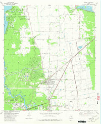
1982 Map of Crosby
USGS Topo · Published 1982About this map
The San Jacinto River corridor in the early 1980s reveals a transition from traditional rural ranching and bayou landscapes to organized suburban development. High-growth communities like Newport and Indian Shores define the western edge along Lake Houston, featuring extensive planned layouts including the Newport Country Club and Golf Course. In contrast, the established settlement of Crosby remains a focal point of infrastructure, where the Southern Pacific railroad intersects major local thoroughfares like Runneburg Road and Krenek Road. The map is particularly rich for genealogical research, documenting several distinct burial grounds including Simms Cem, Sacred Heart Cem, and Evergreen Cem, alongside essential community landmarks like the Sacred Heart Sch and the Fairground.
Find a feature on this map
70 named features on this map. Tap any name to fly to it.
Don’t see what you’re looking for? This feature index may not catch every label — zoom into the map to look around manually.
Map Details
Editions of this 1982 Crosby Map
This is the sole edition of this map. No revisions or reprints were ever made.
Other maps of this area

1916 · Burnett Bay
USGS Topo · 1:24,000

1916 · Crosby
USGS Topo · 1:24,000

1916 · Fauna
USGS Topo · 1:24,000

1916 · Harmaston
USGS Topo · 1:24,000

1916 · Moonshine Hill
USGS Topo · 1:24,000

1916 · Cedar Bayou
USGS Topo · 1:24,000

1916 · Huffman
USGS Topo · 1:24,000

1919 · Crosby
USGS Topo · 1:31,680

1919 · Cedar Bayou
USGS Topo · 1:31,680
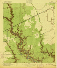
1920 · Fauna
USGS Topo · 1:31,680