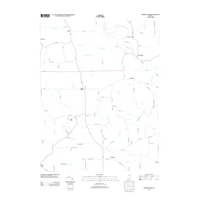
2013 Map of Cross Plains
USGS Topo · Published 2013About this map
Cross Plains serves as the central hub for this portion of Ripley and Switzerland counties, where local transit is defined by the intersection of state routes and a network of named country roads. The topography is dominated by dramatic drainage patterns, with Laughery Cr and Raccoon Cr carving through the landscape. Distinctive geographical formations such as the Devils Backbone and Possum Trot Ridge indicate a terrain of significant elevation changes, characteristic of this region near the Ohio River valley. Smaller hamlets and named locales like Friendship, Avonburg, and Salem Ridge are scattered throughout, connected by winding routes like S Friendship Rd and S Benham Rd. The map documents a rural landscape where agricultural life and natural watercourses, such as Wilson Fork and Little Raccoon Cr, remain the primary features of the land.
Find a feature on this map
97 named features on this map. Tap any name to fly to it.
Don’t see what you’re looking for? This feature index may not catch every label — zoom into the map to look around manually.
Map Details
Editions of this 2013 Cross Plains Map
This is the sole edition of this map. No revisions or reprints were ever made.
Other maps of this area

1943 · Vevay North
USGS Topo · 1:24,000

1946 · Versailles
USGS Topo · 1:24,000

1946 · Milan
USGS Topo · 1:24,000

1953 · Cincinnati
USGS Topo · 1:250,000

1956 · Bennington
USGS Topo · 1:24,000

1956 · Canaan
USGS Topo · 1:24,000

1956 · Louisville
USGS Topo · 1:250,000

1957 · Cincinnati
USGS Topo · 1:250,000
1957 · Vevay North
USGS Topo · 1:24,000

1958 · Dillsboro
USGS Topo · 1:24,000