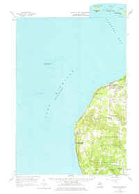
1958 Map of Cross Village
USGS Topo · Published 1977About this map
Cross Village and the remote coastline of northern Emmet County are the primary focus of this late-1950s survey. The landscape is characterized by a mix of established coastal settlements and the dense timber of Hardwood State Forest. The map captures a unique transition where land meets the water, documenting the intricate topography of Mc Cort Hill and Island View Hill alongside the shallow hazards of Lake Michigan such as Dahlia Shoal.
Find a feature on this map
29 named features on this map. Tap any name to fly to it.
Don’t see what you’re looking for? This feature index may not catch every label — zoom into the map to look around manually.
Map Details
Editions of this 1958 Cross Village Map
2 editions found
Other maps of this area

1954 · Charlevoix
USGS Topo · 1:62,500

1955 · Hog Island
USGS Topo · 1:62,500

1955 · Cheboygan
USGS Topo · 1:250,000

1958 · Cheboygan
USGS Topo · 1:250,000

1958 · Cross Village
USGS Topo · 1:62,500

1958 · Pellston
USGS Topo · 1:62,500

1958 · Bayshore
USGS Topo · 1:62,500

1958 · Petoskey
USGS Topo · 1:62,500

1964 · Big Stone Bay
USGS Topo · 1:24,000

1975 · Petoskey NW
USGS Topo · 1:24,000
Featured Places
- Cross Village, MI
- Friendship Township, MI
- Readmond Township, MI
- Cross Village Township, MI
- Middle Village, MI