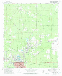
1973 Map of Crossett North
USGS Topo · Published 1975About this map
Crossett and its northern suburbs are the focal point of this mid-1970s topographic study, illustrating the intensive industrial and infrastructure development of southern Arkansas. The landscape is heavily marked by the intersection of four major railroads: the Chicago Rock Island and Pacific, Ashley Drew and Northern, Missouri Pacific, and Arkansas and Louisiana Missouri. This dense rail network, alongside a series of large Gravel Pits, underscores the region's role as a logistical and industrial hub near the Louisiana border.
Find a feature on this map
52 named features on this map. Tap any name to fly to it.
Don’t see what you’re looking for? This feature index may not catch every label — zoom into the map to look around manually.
Map Details
Editions of this 1973 Crossett North Map
This is the sole edition of this map. No revisions or reprints were ever made.
Other maps of this area

1934 · Ingalls
USGS Topo · 1:48,000

1934 · Felsenthal
USGS Topo · 1:62,500

1937 · Felsenthal
USGS Topo · 1:62,500

1937 · Ingalls
USGS Topo · 1:62,500

1938 · Felsenthal
USGS Topo · 1:62,500

1939 · Felsenthal
USGS Topo · 1:62,500

1939 · Ingalls
USGS Topo · 1:62,500

1952 · Fountain Hill
USGS Topo · 1:24,000

1953 · Greenwood
USGS Topo · 1:250,000

1953 · El Dorado
USGS Topo · 1:250,000