1937 Map of Felsenthal
USGS Topo · Published 1937About this map
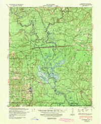
The lowlands of the Ouachita River basin dominate this 1930s landscape, where intricate waterways like Grand Marais and Redeye Lake weave through a terrain defined by ridges and sloughs. This area along the Arkansas-Louisiana border centers on the industrial and transit hubs of Felsenthal and Huttig, both served by the Missouri Pacific railroad. The map illustrates a complex river economy, where Logging RR lines snake through the bottomlands toward Pea Ridge and Horton Island.
Find a feature on this map
97 named features on this map. Tap any name to fly to it.
Don’t see what you’re looking for? This feature index may not catch every label — zoom into the map to look around manually.
Map Details
Editions of this 1937 Felsenthal Map
This is the sole edition of this map. No revisions or reprints were ever made.
Historical Maps of Huttig Through Time
4 maps found