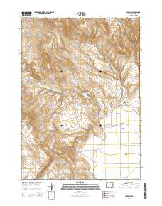
2014 Map of Crowley
USGS Topo · Published 2014About this map
Crowley sits at the heart of this high-desert landscape in southeastern Oregon, where ranching operations are tied to the scattered water sources of Malheur County. The map reveals a network of natural springs and seasonal drainages, including Marking Corral Springs, Whiskey Springs, and Jurries Springs, which feed into Little Crowley Cr and Crowley Cr. These water points support the local fields, notably Porter Field and Long Field, demonstrating the traditional land-use patterns of the Great Basin. To the west, the terrain rises sharply toward Stockade Mtn and Star Mtn, while the eastern edge is defined by the expanse of Barren Valley. Infrastructure is sparse, centered on the Crowley Ranch Airstrip and the winding Crowley-Riverside Rd, reflecting the isolation of this corner of the state during the early 21st century.
Find a feature on this map
29 named features on this map. Tap any name to fly to it.
Don’t see what you’re looking for? This feature index may not catch every label — zoom into the map to look around manually.
Map Details
Editions of this 2014 Crowley Map
This is the sole edition of this map. No revisions or reprints were ever made.
Other maps of this area

1955 · Burns
USGS Topo · 1:250,000

1955 · Boise
USGS Topo · 1:250,000

1958 · Burns
USGS Topo · 1:250,000

1958 · Boise
USGS Topo · 1:250,000

1959 · Burns
USGS Topo · 1:250,000

1962 · Boise
USGS Topo · 1:250,000

1972 · Burnt Flat
USGS Topo · 1:24,000

1972 · Crowley
USGS Topo · 1:24,000
1972 · Sacramento Butte
USGS Topo · 1:24,000
1972 · Mustang Butte
USGS Topo · 1:24,000