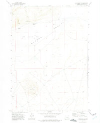
1972 Map of Mustang Butte
USGS Topo · Published 1975About this map
Mustang Butte dominates the southern landscape of this Malheur County interior, rising above a vast and largely arid basin. In the early 1970s, the region was characterized by the sprawling Barren Valley and the dry expanse of the Piute Lake Bed, reflecting the high desert hydrology of eastern Oregon. Evidence of cattle ranching and government land management is found at the Crowley Guard Station and nearby Corral, while the presence of a Landing Strip and Mooreville (Site) suggests earlier attempts at more permanent settlement or specialized transit in this isolated area. The drainage of Piute Creek and the small Cook Reservoir represent the vital, limited water resources essential for survival in this environment. Several dry wells and scattered springs like Piute Spring highlight the constant search for water across this section of the Oregon outback.
Find a feature on this map
14 named features on this map. Tap any name to fly to it.
Don’t see what you’re looking for? This feature index may not catch every label — zoom into the map to look around manually.
Map Details
Editions of this 1972 Mustang Butte Map
This is the sole edition of this map. No revisions or reprints were ever made.
Other maps of this area

1955 · Burns
USGS Topo · 1:250,000

1955 · Boise
USGS Topo · 1:250,000

1958 · Burns
USGS Topo · 1:250,000

1958 · Boise
USGS Topo · 1:250,000

1959 · Burns
USGS Topo · 1:250,000

1962 · Boise
USGS Topo · 1:250,000
1972 · Wrangle Butte
USGS Topo · 1:24,000
1972 · Saddle Butte
USGS Topo · 1:24,000

1972 · Burnt Flat
USGS Topo · 1:24,000

1972 · Crowley
USGS Topo · 1:24,000