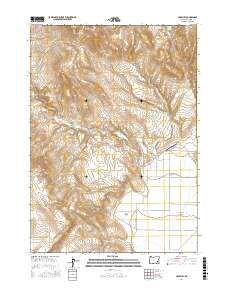
2017 Map of Crowley
USGS Topo · Published 2017About this map
Crowley anchors this high-desert landscape in Malheur County, situated at the intersection of Crowley-Riverside Rd and Crowley Rd. The area is defined by its vital water sources, including the centrally located Crowley Reservoir and a series of naming-rights springs such as Whiskey Springs, Porter Spring, and Jurries Springs. The topographic relief is dominated by Star Mtn and Stockade Mtn, which overlook agricultural and grazing lands like Long Field and the aptly named Barren Valley. Evidence of the region's isolated ranching infrastructure is seen in the Crowley Ranch Airstrip, providing a critical link to this remote portion of southeastern Oregon. The map detail highlights the importance of seasonal drainages like Little Crowley Cr and Rapid Cr in an environment where water access dictates the pattern of human activity and settlement.
Find a feature on this map
24 named features on this map. Tap any name to fly to it.
Don’t see what you’re looking for? This feature index may not catch every label — zoom into the map to look around manually.
Map Details
Editions of this 2017 Crowley Map
This is the sole edition of this map. No revisions or reprints were ever made.
Other maps of this area

1955 · Burns
USGS Topo · 1:250,000

1955 · Boise
USGS Topo · 1:250,000

1958 · Burns
USGS Topo · 1:250,000

1958 · Boise
USGS Topo · 1:250,000

1959 · Burns
USGS Topo · 1:250,000

1962 · Boise
USGS Topo · 1:250,000

1972 · Burnt Flat
USGS Topo · 1:24,000

1972 · Crowley
USGS Topo · 1:24,000
1972 · Sacramento Butte
USGS Topo · 1:24,000
1972 · Mustang Butte
USGS Topo · 1:24,000