
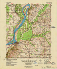
1952 Map of Crutchfield
USGS Topo · Published 1953About this map
Crutchfield and the surrounding agricultural landscapes of Hickman and Fulton Counties are defined by the winding course of Bayou du Chien. In the early 1950s, this area of Western Kentucky shows a high density of rural institutions, from the Ledbetter Sch and Mt Carmel Ch to the scattered family burial grounds like Huddleston Cem. The Illinois Central railroad cuts diagonally across the terrain, serving as a vital corridor for the small communities of Beelerton and Riceville.
Find a feature on this map
28 named features on this map. Tap any name to fly to it.
Don’t see what you’re looking for? This feature index may not catch every label — zoom into the map to look around manually.
Map Details
Editions of this 1952 Crutchfield Map
This is the sole edition of this map. No revisions or reprints were ever made.
Other maps of this area

1939 · Hickman
USGS Topo · 1:62,500

1951 · Cayce
USGS Topo · 1:24,000

1951 · Oakton
USGS Topo · 1:24,000

1952 · Clinton
USGS Topo · 1:24,000

1952 · Dublin
USGS Topo · 1:24,000

1952 · Water Valley
USGS Topo · 1:24,000

1952 · Water Valley
USGS Topo · 1:62,500

1954 · Union City
USGS Topo · 1:24,000

1954 · Hickman
USGS Topo · 1:62,500
1955 · Hickman
USGS Topo · 1:62,500