
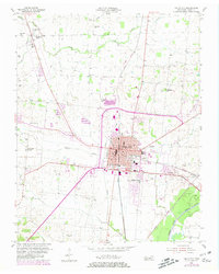
1954 Map of Union City
USGS Topo · Published 1955About this map
Union City stands as a bustling regional hub in the mid-1950s, defined by the intersection of the Gulf Mobile and Ohio and Illinois Central railroads. This detailed survey captures the town's mid-century footprint, from the central Courthouse and Armory to the outlying County Hospital. The surrounding Obion County landscape is a mosaic of small farming communities and rural spiritual centers, such as Woodland Mills and Gibbs. Genealogists will find a wealth of specific data in the numerous family-named burial grounds and churches scattered across the terrain, including the Wise-Holloway Cem, Scott Cem, and Beulah Ch. To the southeast, the North Fork Obion River meanders through bottomlands, while various tributaries like Reelfoot Creek and Hoosier Creek drain the undulating hills, illustrating the natural water system that influenced local settlement patterns before modern development.
Find a feature on this map
38 named features on this map. Tap any name to fly to it.
Don’t see what you’re looking for? This feature index may not catch every label — zoom into the map to look around manually.
Map Details
Editions of this 1954 Union City Map
2 editions found
Other maps of this area

1939 · Hickman
USGS Topo · 1:62,500

1950 · Obion
USGS Topo · 1:24,000

1950 · Rives
USGS Topo · 1:24,000

1951 · Obion
USGS Topo · 1:24,000

1951 · Rives
USGS Topo · 1:24,000

1951 · Cayce
USGS Topo · 1:24,000

1951 · Hickman
USGS Topo · 1:24,000

1952 · Crutchfield
USGS Topo · 1:24,000

1952 · Water Valley
USGS Topo · 1:62,500

1954 · Hickman
USGS Topo · 1:62,500