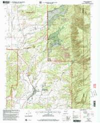
2002 Map of Cuba
USGS Topo · Published 2003About this map
Cuba sits as a central hub at the edge of the Santa Fe National Forest in this early 21st-century record. The map details the civic infrastructure of the valley, featuring the High Sch, Elementary School, and the Cuba Ranger Sta alongside the Rodeo Ground. This landscape is defined by the transition from high forest lands to the arid Mesa de Cuba, with water management and livestock patterns evident in features like the Circle A Ranch and various Cems.
Find a feature on this map
30 named features on this map. Tap any name to fly to it.
Don’t see what you’re looking for? This feature index may not catch every label — zoom into the map to look around manually.
Map Details
Editions of this 2002 Cuba Map
This is the sole edition of this map. No revisions or reprints were ever made.
Other maps of this area

1883 · Mt. Taylor
USGS Topo · 1:250,000

1886 · Mt. Taylor
USGS Topo · 1:250,000

1889 · Largo
USGS Topo · 1:250,000

1890 · Jemes
USGS Topo · 1:125,000

1892 · Jemes
USGS Topo · 1:125,000

1892 · Mt. Taylor
USGS Topo · 1:250,000

1895 · Largo
USGS Topo · 1:250,000

1899 · Mt. Taylor
USGS Topo · 1:250,000

1909 · Gallina
USGS Topo · 1:125,000

1939 · La Ventana
USGS Topo · 1:62,500