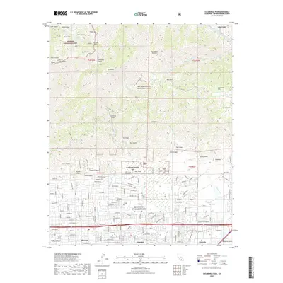
2018 Map of Cucamonga Peak
USGS Topo · Published 2018About this map
Rancho Cucamonga and its neighboring communities of Alta Loma and Etiwanda sit at the southern foot of the San Gabriel Mountains in this 2018 survey. The transition from urban development to the steep wilderness of the San Bernardino National Forest is immediate, defined by a network of drainage washes like Day Creek and Deer Cr. While much of the lowlands are densely gridded with residential streets, remnants of the region's agricultural past are visible in labels for the Pacific Electric Trail, which traces a historic transit corridor through Grapeland. Higher elevations are dominated by formidable summits including Cucamonga Peak, Bighorn Peak, and Ontario Peak. In the northern canyons, features such as Icehouse Saddle and Cucamonga Canyon illustrate the headwaters of the regional watershed before it flows into the developed Inland Empire valley near Chaffey College.
Find a feature on this map
166 named features on this map. Tap any name to fly to it.
Don’t see what you’re looking for? This feature index may not catch every label — zoom into the map to look around manually.
Map Details
Editions of this 2018 Cucamonga Peak Map
This is the sole edition of this map. No revisions or reprints were ever made.
Other maps of this area

1896 · San Bernardino
USGS Topo · 1:62,500

1897 · Cucamonga
USGS Topo · 1:62,500

1898 · San Bernardino
USGS Topo · 1:62,500

1900 · Cucamonga
USGS Topo · 1:62,500

1901 · Southern California Sheet No. 1
USGS Topo · 1:250,000

1901 · San Bernardino
USGS Topo · 1:62,500

1902 · Hesperia
USGS Topo · 1:62,500

1903 · Cucamonga
USGS Topo · 1:62,500

1903 · San Antonio
USGS Topo · 1:62,500

1904 · Southern California Sheet No. 1
USGS Topo · 1:250,000