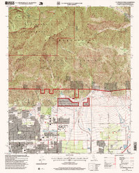
1996 Map of Cucamonga Peak
USGS Topo · Published 1999About this map
Rancho Cucamonga and the neighboring communities of Alta Loma and Etiwanda sit at the dramatic interface between the urbanized San Bernardino Valley and the steep San Gabriel Mountains. This 1996 revision documents the residential expansion of these citrus-growing colonies toward the edge of the San Bernardino National Forest. While the lower elevations are marked by a formal grid including Archibald Ave and Highland Ave, the northern half of the map is dominated by high-altitude peaks like Mount Baldy, Cucamonga Peak, and Telegraph Peak. The landscape is defined by the alluvial drainage systems of Day Creek and Deer Creek, which flow from deep incisions like Day Canyon into the developed valley below. Educational landmarks such as Chaffey Union Junior College and local institutions like the Summit Avenue School serve as anchors for the local community during this period of suburban transition.
Find a feature on this map
50 named features on this map. Tap any name to fly to it.
Don’t see what you’re looking for? This feature index may not catch every label — zoom into the map to look around manually.
Map Details
Editions of this 1996 Cucamonga Peak Map
This is the sole edition of this map. No revisions or reprints were ever made.
Other maps of this area

1896 · San Bernardino
USGS Topo · 1:62,500

1897 · Cucamonga
USGS Topo · 1:62,500

1898 · San Bernardino
USGS Topo · 1:62,500

1900 · Cucamonga
USGS Topo · 1:62,500

1901 · Southern California Sheet No. 1
USGS Topo · 1:250,000

1901 · San Bernardino
USGS Topo · 1:62,500

1902 · Hesperia
USGS Topo · 1:62,500

1903 · Cucamonga
USGS Topo · 1:62,500

1903 · San Antonio
USGS Topo · 1:62,500

1904 · Southern California Sheet No. 1
USGS Topo · 1:250,000