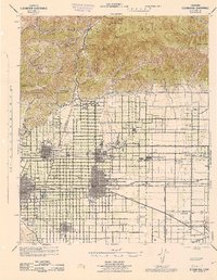
1944 Map of Cucamonga
USGS Topo · Published 1944About this map
The San Gabriel Mountains rise sharply above a meticulously gridded landscape of citrus groves and expanding settlements in this mid-1940s survey. The cultural heart of the region is centered on the educational institutions of Claremont, including Pomona College and Scripps College, while the Padua Hills Theater stands at the base of the foothills. Transportation defines the valley's layout, with the Atchison Topeka and Santa Fe and Pacific Electric rail lines cutting through the hearts of Upland, Cucamonga, and Ontario.
Find a feature on this map
82 named features on this map. Tap any name to fly to it.
Don’t see what you’re looking for? This feature index may not catch every label — zoom into the map to look around manually.
Map Details
Editions of this 1944 Cucamonga Map
This is the sole edition of this map. No revisions or reprints were ever made.
Other maps of this area

1894 · Pomona
USGS Topo · 1:62,500

1896 · Anaheim
USGS Topo · 1:62,500

1896 · San Bernardino
USGS Topo · 1:62,500

1897 · Pomona
USGS Topo · 1:62,500

1897 · Cucamonga
USGS Topo · 1:62,500

1898 · Pomona
USGS Topo · 1:62,500

1898 · San Bernardino
USGS Topo · 1:62,500

1898 · Anaheim
USGS Topo · 1:62,500

1900 · Cucamonga
USGS Topo · 1:62,500

1901 · Southern California Sheet No. 1
USGS Topo · 1:250,000