
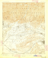
1898 Map of Pomona
USGS Topo · Published 1898About this map
The San Gabriel Timber Reserve dominates the northern half of this 1894 survey, protecting the steep canyons and ridges of the San Gabriel Mountains before they descend into the rapidly developing citrus and agricultural valleys below. This period captures the early footprint of the San Gabriel Valley's railroad towns, where the Southern Pacific Railroad and the Atchison Topeka and Santa Fe Railroad dictated the growth of settlements like Azusa, Covina, and Lordsburg. Large Mexican land grant divisions such as La Puente and San Jose are still clearly delineated, showing the transition from ranchos to subdivided townships. Water infrastructure is critical to the landscape, evidenced by the Azusa Ditch and Covina Canal drawing from the San Gabriel River. The map also preserves vanished or renamed place names from the late nineteenth century, including Alosta and Rowland Siding.
Find a feature on this map
66 named features on this map. Tap any name to fly to it.
Don’t see what you’re looking for? This feature index may not catch every label — zoom into the map to look around manually.
Map Details
Editions of this 1898 Pomona Map
2 editions found
Other maps of this area

1894 · Los Angeles
USGS Topo · 1:62,500

1894 · Pomona
USGS Topo · 1:62,500

1896 · Pasadena
USGS Topo · 1:62,500

1896 · Anaheim
USGS Topo · 1:62,500

1896 · Downey
USGS Topo · 1:62,500

1897 · Pomona
USGS Topo · 1:62,500

1897 · Cucamonga
USGS Topo · 1:62,500

1898 · Anaheim
USGS Topo · 1:62,500

1899 · Downey
USGS Topo · 1:62,500

1900 · Pasadena
USGS Topo · 1:62,500