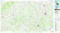
1985 Map of Cuero
USGS Topo · Published 1991About this map
The Guadalupe River and San Marcos River converge in the northern portion of this South Texas region, framing a landscape defined by cattle ranching and early transportation corridors. The city of Cuero serves as a central hub, flanked by regional centers like Yoakum and Gonzales. Smaller communities such as Shiner and Stockdale are connected by a network of state highways and the Southern Pacific railroad, illustrating the agricultural and industrial links that sustained DeWitt and Gonzales counties into the late twentieth century.
Find a feature on this map
101 named features on this map. Tap any name to fly to it.
Don’t see what you’re looking for? This feature index may not catch every label — zoom into the map to look around manually.
Map Details
Editions of this 1985 Cuero Map
2 editions found
Other maps of this area

1901 · Flatonia
USGS Topo · 1:125,000

1911 · San Marcos
USGS Topo · 1:125,000

1919 · San Marcos
USGS Topo · 1:125,000

1919 · Schulenburg
USGS Topo · 1:62,500

1920 · Smiley
USGS Topo · 1:125,000

1924 · New Braunfels No 4
USGS Topo · 1:48,000

1924 · San Marcos 3-c
USGS Topo · 1:48,000

1924 · San Marcos 3-d
USGS Topo · 1:48,000

1925 · San Marcos 4-c
USGS Topo · 1:48,000

1925 · Tordia No. 1
USGS Topo · 1:48,000