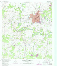
1960 Map of Cuero
USGS Topo · Published 1987About this map
The Guadalupe River winds through the heart of this DeWitt County landscape, anchoring the development of Cuero as a regional transportation and civic hub. The town's grid is defined by thoroughfares like Esplanade Street and Broadway, with the Southern Pacific railroad and an Old Railroad Grade tracing the historical movement of goods and people across the plains. Rural life is anchored by outlying points like Lindenau and schools such as Clinton Sch and Ratcliffe Sch.
Find a feature on this map
49 named features on this map. Tap any name to fly to it.
Don’t see what you’re looking for? This feature index may not catch every label — zoom into the map to look around manually.
Map Details
Editions of this 1960 Cuero Map
Other maps of this area

1953 · Beeville
USGS Topo · 1:250,000

1953 · Seguin
USGS Topo · 1:250,000

1956 · Beeville
USGS Topo · 1:250,000

1958 · Seguin
USGS Topo · 1:250,000

1960 · Beeville
USGS Topo · 1:250,000

1960 · Cuero
USGS Topo · 1:24,000

1960 · Concrete
USGS Topo · 1:24,000

1960 · Blackwell Lake
USGS Topo · 1:24,000

1960 · Westhoff
USGS Topo · 1:24,000

1962 · Verhelle
USGS Topo · 1:24,000