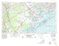
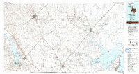
1953 Map of Beeville
USGS Topo · Published 1953About this map
Victoria and Beeville anchor this mid-century survey of the Texas Coastal Bend, where the prairie transitions into a complex network of bays and barrier islands. The landscape is defined by the convergence of major waterways including the San Antonio River, Guadalupe River, and Nueces River as they flow toward Matagorda Bay and Aransas Bay. Of particular significance is the Aransas National Wildlife Refuge, established on the Blackjack Peninsula to protect the wintering grounds of endangered species. The map illustrates a region deeply connected to its maritime and agricultural roots, showing a dense network of railroads like the Southern Pacific RR and Missouri Pacific RR that linked coastal ports like Port Lavaca and Palacios to the interior cattle and farming hubs. Military presence is also noted along the coast with designated areas such as the Matagorda Island Gunnery and Bombing Range, reflecting the era's strategic coastal defense and training requirements.
Find a feature on this map
199 named features on this map. Tap any name to fly to it.
Don’t see what you’re looking for? This feature index may not catch every label — zoom into the map to look around manually.
Map Details
Editions of this 1953 Beeville Map
This is the sole edition of this map. No revisions or reprints were ever made.
Historical Maps of Victoria Through Time
4 maps found